Road Work Exclusion Zones
From 15 January to 4 March there will be road disruptions throughout 2024.
What is happening?
Wurundjeri Way will be closed to traffic from Monday 15th January to Monday 4th March 2024 to allow the West Gate Tunnel Project to continue construction of a brand-new bridge and elevated roadway.
Footscray Road will see lane closures and full closures between 12 February and 4 March to allow the construction of a cable stay bridge for the new shared user path.
At the same time, significant work will be undertaken on the West Gate Freeway between Williamstown Road and the M80 Ring Road, with reduced lane capacity in each direction.
This will put pressure on our road and public transport networks, particularly in and around the CBD, along the West Gate Freeway, and in the western suburbs.
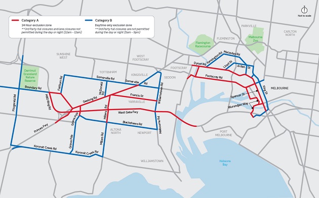
View a larger version of the map
What are we doing?
During this time of disruption, we are asking the transport industry and partners to adhere to a road works exclusion zone that takes in key arterials across Melbourne (see map & list).
This exclusion zone is designed to help the community navigate the expected busy conditions.
The exclusion zone follows an effective strategy employed in late 2023, however following a thorough analysis, the number of arterial roads subject to a road work exclusion can be reduced around the Wurundjeri Way / Footscray Road closure, while still allowing for acceptable levels of network performance.
New arterial roads have been incorporated throughout inner west and western suburbs to facilitate significant work on the West Gate Freeway. This exclusion zone will be incorporated to the zone around Wurundjeri Way and Footscray Road.
What works will be impacted?
We are asking for all works that will impact or close trafficable lanes to be postponed during this period. Works that don’t impact the road network (like footpath repairs or landscaping) can continue, although we’re asking that you inform us of the location and time they are happening to help us better manage the network. Some exceptions may
be possible, for example, for safety issues, or if scheduled works are to take place between 9pm & 5am - we will work through on a case‑by-case basis to analyse the potential impacts.
Emergency works
Emergencies can’t be planned for; however, we are asking partners to use our escalation process to inform us of location, time and impact when they do happen. By having oversight of these emergencies, we may be able to intervene to reduce the impact to traffic by adjusting traffic signals, displaying electronic messaging or by providing incident response or traffic management advice.
How do you help?
Please follow normal procedures when submitting your MOA’s – you’ll find instructions on the portal with details of the exclusion zone and the times and dates to avoid work. If you already have an approved MOA within the exclusion zone, someone from DTP will be in touch directly with you.
Escalate any emergency or utility works in your area of authority to the Transport Operations Centre on 13 11 70
Key Arterials subject to roadwork exclusion
- Entirety of Docklands precinct
- King St from Victoria St to Flinders St both directions
- Flinders St from West Gate Freeway to King St both directions
- Spencer Street from Clarendon Street to Dynon Road
- Harbour Esplanade from Collins Street to Footscray Road
- Footscray Rd on the approach to Dudley St/ Harbour Esplanade
- Dynon Rd/ Spencer St from Citylink to Flinders St both directions
- Footscray Rd on the inbound approach to the Citylink interchange
- Dynon Rd on the inbound approach to the Citylink interchange
- LaTrobe Street from King Street to Harbour Esplanade
- Collins Street from King Street to Harbour Esplanade
- Dudley Street from Peel Street to Wurundjeri Way
- Moore Street from Ballarat Road to Hopkins Street
- Dynon Road from Dryburgh Street to Hopkins Street
- Hopkins Street from Dynon Road to Moore Street
- Dock Link Road from Dynon Road to Footscray Road
- Footscray Road from Wurundjeri Way to Moreland Street
- Kensington Rd from Dynon Rd to Arden St
- Arden St from Kensington Rd to Curzon St
- Curzon St from Arden St to King St
- Dryburgh St from Dynon Rd to Arden St
- Hawke St from King St to Spencer St
- Moreland Street from Footscray Road to Whitehall Street
- Napier Street from Moreland Street to Hyde Street
- Hyde Street from Napier Street to Douglas Parade
- Whitehall Street from Hopkins Street to Francis Street
- Williamstown Road from Geelong Street to the West Gate Freeway
- Somerville Road from Whitehall St to Fairburn Road
- Melbourne Road from Blackshaws Road to the West Gate Freeway
- Blackshaws Road from Millers Road to Melbourne Road
- West Gate Freeway in both directions between the West Gate Bridge and M80 Ring Road
- Princes Freeway in both directions between the M80 Ring Road and Kororoit Creek Road
- M80 Ring Road in both directions between Boundary Road and the West Gate Freeway
- Geelong Road in both directions between the M80 and Ballarat Road
- Francis Street between Geelong Road and Whitehall Street
- Millers Road between Geelong Road and Kororoit Creek Road
- Grieve Parade between Geelong Road and Dohertys Road
- Little Boundary Road between Geelong Road and Boundary Road
- Boundary Road between Fairburn Road and Robinsons Road
- Fairburn Road between Boundary Road and Somerville Road
- McDonald Road between Geelong Road and Somerville Road
- Robinsons Road between Boundary Road and the Deer Park Bypass
- Kororoit Creek Road between Fitzgerald Road and Millers Road
- Fitzgerald Road between Kororoit Creek Road and the Deer Park Bypass